No edit summary Tag: sourceedit |
No edit summary Tag: sourceedit |
||
| Line 286: | Line 286: | ||
|1.34 mi |
|1.34 mi |
||
|Short-lived tornado confirmed by law enforcement. A few trees were downed, but damage was otherwise minimal. |
|Short-lived tornado confirmed by law enforcement. A few trees were downed, but damage was otherwise minimal. |
||
| + | |- |
||
| + | | bgcolor="#{{Storm colour|cat3}}" | <big>'''EF3'''</big> |
||
| + | |'''S of Danvers to Benson to Swift Falls''' |
||
| + | |Swift |
||
| + | |1909 |
||
| + | |18 mi |
||
| + | |'''1 death''' - this EF3 tornado began south of Danvers in rural areas. It quickly grew to a large wedge tornado and completely destroyed a farm house and outbuildings near it. Trees were slightly debarked as it crossed the Chippewa River and neared Benson. It entered the southern part of Benson where several homes were left with only interior walls standing, and grain bins were toppled. Two homes on 10th street were nearly flattened, and one person was killed there. A few businesses on Route 12 sustained significant damage, and a farming plant east-northeast of town was heavily damaged. It continued northeast through rural areas until dissipating near Swift Falls. |
||
|- |
|- |
||
| colspan="7" style="text-align:center;" |'''Iowa''' |
| colspan="7" style="text-align:center;" |'''Iowa''' |
||
Revision as of 22:35, 1 December 2016
 | |
| Type: | Unknown |
| Active: | June 8-11, 2018 |
| Duration of tornado outbreak1: | 4 days, 6 hours, 12 minutes |
| Maximum rated tornado2: | EF4 tornado |
| Highest winds | Unknown |
| Tornadoes confirmed: | 141 |
| Damage: | $1.66 billion (2018 USD) |
| Injuries: | Unknown |
| Fatalities: | 41 |
| Areas affected: | North Dakota, South Dakota, Minnesota, Wisconsin, Illinois, Indiana, Michigan, Ohio |
|
1Time from first tornado to last tornado | |
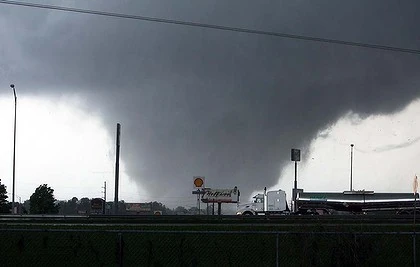
As a powerful shortwave trough dropped into the northern United States and move east-southeast, the stage was being set for a multi-day tornado outbreak in the upper Midwest. The Storm Prediction Center had every day on its 4-8 outlook marked for severe weather on June 5. June 8 featured high instability and good shear, but a cap that didn't erode until mid afternoon. The SPC had an enhanced risk with a 10% hatched tornado risk in place for much of central and east North Dakota and South Dakota, with a 5% risk extending into northern Nebraska. 24 tornadoes touched down that day, including one EF4. The most prolific day of the outbreak took place on June 9. A strong surface low was located near the North Dakota/Minnesota border, with a cold front draping down through west MN into northern IA. A warm front in central/north MN was also expected to be a focus for tornadic activity later that day. 0-1 km helicity was in the 300-500 m2/s2 range and MLCAPE exceeded 4,000 j/kg in some spots. The SPC issued a moderate risk with a 15% hatched tornado risk for much of central and southern MN, which was eventually upgraded to a high risk at the 2000z outlook. A PDS tornado watch was issued and several long-tracked, intense supercells developed spawning 54 tornadoes, including 8 EF4's. After dark, storms congealed into an MCS, and a few QLCS tornadoes occurred. By morning, the MCS had weakened, and rapid destabilization occurred in north Illinois and southern Wisconsin. The surface low had moved southeast quite a bit, now positioned in northeast Iowa. Again, a moderate risk was issued with a 15% hatched tornado risk. 31 tornadoes touched down, including two EF4's, one of which had a path length of about 91 miles. Activity became sloppy and another MCS formed that evening, but it weakened before dawn on June 11. Another moderate risk was issued that day. The surface low was located in extreme southwest Michigan, and the whole warm sector was primed for supercells and tornadoes. 32 tornadoes touched down, including two long-tracked EF4's. Some areas hit in the April 23, 2018 Ohio Tornado Outbreak were hit again in this outbreak. 41 people died in the outbreak, and it left $1.66 billion in damages. 141 tornadoes were confirmed over the four day period, 13 of which were violent.
Tornado Statistics
| State | Total | EF0 | EF1 | EF2 | EF3 | EF4 | EF5 |
|---|---|---|---|---|---|---|---|
| June 8 | 24 | 7 | 8 | 6 | 2 | 1 | 0 |
| June 9 | 54 | 11 | 9 | 16 | 10 | 8 | 0 |
| June 10 | 31 | 6 | 15 | 4 | 4 | 2 | 0 |
| June 11 | 32 | 12 | 8 | 5 | 5 | 2 | 0 |
| Total | 141 | 36 | 40 | 31 | 21 | 13 | 0 |
List of Confirmed Tornadoes
June 8 Event
| State | Total |
|---|---|
| Minnesota | 23 |
| Illinois | 8 |
| Indiana | 5 |
| Iowa | 2 |
| Ohio | 2 |
| Michigan | 1 |
| Totals | 41 |
June 9 Event
| List of confirmed tornadoes - June 8, 2018 | ||||||
|---|---|---|---|---|---|---|
| North Dakota | ||||||
| EF2 | S of Napoleon | Logan | 2147 | 7.2 mi | Stovepipe tornado remained in mainly open areas. A farm home was severely damaged, however. Formed near the triple point in central North Dakota. | |
| EF1 | SW of Streeter to Medina | Stutsman | 2208 | 18.97 mi | Wedge tornado remained in mainly rural areas as it moved north-northeast. Spawned by a supercell along the warm front. | |
| EF0 | E of Fort Yates | Emmons | 2213 | 4 mi | Weak tornado remained in open fields. | |
| EF3 | Jamestown | Stutsman | 2249 | 2.89 mi | Intense yet relatively brief tornado that formed along the warm front in east central North Dakota. Several homes and businesses were destroyed on the south side of town at mid-range EF3 strength, many with only interior walls left standing. 39 people were injured. The tornado cost about $10 million in damages. | |
| EF1 | Linton area | Emmons | 2316 | 3.55 mi | A few mobile homes were damaged south of Linton and trees were downed. Spawned by the same supercell that produced the tornado east of Fort Yates. | |
| EF1 | N of Guyson | Logan | 2333 | 8.11 mi | Weak tornado remained in open fields. Two outbuildings were destroyed and a farm was damaged. | |
| EF0 | N of Guyson | Logan | 2338 | 1 mi | Satellite tornado observed by chasers to the previous event. Produced no damaged. | |
| EF0 | SW of Jud (1st tornado) | LaMoure | 0028 | 5 mi | Produced no known damage. Spawned by the Guyson supercell. | |
| EF1 | SW of Jud (2nd tornado) | LaMoure | 0032 | .8 mi | Occured simultaneously with the previous tornado. Three outbuildings sustained minor damage and telephone poles were downed before the tornado abruptly dissipated. | |
| EF2 | W of Daily | Barnes | 0112 | 9.5 mi | Dozens of trees were denuded and snapped. A pick-up truck was rolled six times and a poorly constructed home was destroyed. | |
| South Dakota | ||||||
| EF4 | ENE of Java to SE of Hillsview | Walworth, Edmunds, McPherson | 2221 | 14.6 mi | Large and violent tornado. Caused severe ground scouring as it passed north of Bowdle. Two farmsteads were completely swept away and a well-constructed home was flattened. An isolated grove of trees was severely debarked, as well. Damage was otherwise limited. | |
| EF3 | ENE of Hillsview to E of Long Lake | McPherson | 2258 | 25.12 mi | Touched down soon after the Java to Hillsview EF4 lifted. Remained in open farmland for much of its lifetime, however a tractor was thrown over 250 yards and crushed. Several outbuildings were completely destroyed and grain bins were toppled and crushed. An irrigation pivot was also severely mangled. | |
|
EF0 |
NE of Hillsview | McPherson | 2309 | 3 mi | Satellite tornado to the previous event. | |
| EF2 | WSW of Agar to SSE of Seneca | Sully, Potter, Faulk | 2312 | 37.3 mi | Long-tracked tornado that was on the ground for nearly an hour and a half. It began in rural areas outside of Agar, and proceeded into the small town. Almost every building in Agar sustained some level of damage, the worst of which was rated EF2. The tornado didn't damage any other structures after hitting Agar, and continued in open fields until dissipating south of Seneca. | |
| EF0 | W of Fort Thompson | Lyman | 2320 | 1 mi | Brief tornado confirmed by chasers. | |
| EF0 | E of Winner | Tripp | 2345 | 2.51 mi | A patch of shrubs and an outbuilding sustained minor damage. | |
| EF2 | Aberdeen | Brown | 2359 | 10.39 mi | Tornado began in fields southwest of Aberdeen and proceeded north-northeast. As it neared the west side of the city, a PDS tornado warning was issued. Several homes in the Derian Subdivision were severely damaged at high-end EF2 strength. To the northeast, numerous other homes sustained EF2 damage on the southwest side of Aberdeen. It crossed Route 12 and threw a parked car one block, as well as heavily damaging Lincoln Elementary School. Many more businesses and homes took damage on the northwest side of town before the tornado returned to rural areas north of the city, where the roof of the Odde Ice Arena caved in. It dissipated west of the Devian Villa Development, injuring 103 people and leaving $100 million in damages. | |
| EF2 | W of Stickney | Aurora | 0018 | 6.12 mi | Long-lived, large, nearly stationary wedge tornado. Began and immediately inflicted EF2 damaged to a farm home and several outbuildings. Turned north and passed very close to another farm house and did EF1 damage to it. At that point it stopped moving and grew to almost 1.5 miles wide, before looping around and denuding trees and destroying outbuildings just west of Stickney. 1 person was injured. | |
| EF1 | ESE of Seneca | Faulk | 0050 | 7.23 mi | Began shortly after the Agar EF2 lifted. A small farm was damaged and a car was pushed off of Route 212. | |
| EF1 | W of St. Lawrence | Hand | 0144 | 4.4 mi | A church and three homes were damaged as the tornado passed over Route 14 between Miller and St. Lawrence. The roof of the church was thrown about 200 yards to the northeast in a field. | |
| EF1 | Kampeska | Codington | 0251 | 12.4 mi | A few double wide homes sustained roof and garage damage in Kampeska. Several more homes were damaged on the west side of Lake Kampeksa, and three people were injured. Telephone poles were downed, as well. | |
| EF1 | N of Lake Kampeska | Tripp | 0335 | 1.68 mi | Outbuildings were damaged and several trees were downed. Formed as the Kampeska tornado dissipated. | |
| Nebraska | ||||||
| EF2 | Bassett area | Rock | 0134 | 5.88 mi | Slow-moving, large, high-end EF2 tornado that did significant damage to the southern half of Bassett. Several homes lost their rooves and some had only a few walls remaining. 28 people were injured. | |
| EF0 | N of Atkinson | Holt | 0217 | 0.2 mi | Local sherif reported a tornado. Produced no known damage other than to crops. | |
June 10 Event
| List of confirmed tornadoes - June 9, 2018 | ||||||
|---|---|---|---|---|---|---|
| Minnesota | ||||||
| EF0 | E of Forada | Douglas | 1837 | 1.34 mi | Short-lived tornado confirmed by law enforcement. A few trees were downed, but damage was otherwise minimal. | |
| EF3 | S of Danvers to Benson to Swift Falls | Swift | 1909 | 18 mi | 1 death - this EF3 tornado began south of Danvers in rural areas. It quickly grew to a large wedge tornado and completely destroyed a farm house and outbuildings near it. Trees were slightly debarked as it crossed the Chippewa River and neared Benson. It entered the southern part of Benson where several homes were left with only interior walls standing, and grain bins were toppled. Two homes on 10th street were nearly flattened, and one person was killed there. A few businesses on Route 12 sustained significant damage, and a farming plant east-northeast of town was heavily damaged. It continued northeast through rural areas until dissipating near Swift Falls. | |
| Iowa | ||||||
| Wisconsin | ||||||
June 11 Event
| List of confirmed tornadoes - June 10, 2018 | ||||||
|---|---|---|---|---|---|---|
| Wisconsin | ||||||
| Illinois | ||||||
| List of confirmed tornadoes - June 11, 2018 | |||||
|---|---|---|---|---|---|