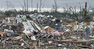
The June 24-26 Super Outbreak was a significant tornado outbreak that took place in the Great Lakes Region, and caused over 20 Billion Dollars in Damage. It is considered the most destructive tornado in the Great Lakes region on record, with many violent tornadoes and thousands of fatalities that occured from the early hours of June 24 to the late hours of June 26.
Contents
1 Meteorological Synopsis 2 Confirmed Tornadoes
3 Notable Tornadoes
3.1 Ann Arbor Area Tornadoes
3.2 Ypsilanti Tornado
3.3 Battle Creek-Albion-Parma-Woodville-Jackson Tornado
3.4 Chesterton-Porter-Michigan City-New Buffalo-Baroda-Shoreham-St. Joseph-Benton Harbor Tornado
3.5 Holland-Zeeland-Hudsonville-Grandville-Grand Rapids Tornado
3.6 Owosso Area Tornadoes
3.7 Peru-Mendota Tornado
3.8 Chicago Area Tornadoes
3.9 Kettering-Dayton-Springfield-Marysville-Marion-Galion-Mansfield Tornado
3.10 Columbus Area Tornadoes
3.11 Nashville-Mount Juliet Tornado
3.12 Cookeville-Knoxville Tornado
3.13 De Witt-Elvira-Clinton-Fulton Tornado
3.14 Romulus Tornado
3.15 Detroit Area Tornadoes
3.16 Florence Tornado
3.17 Northport Tornado
3.18 Traverse City Tornado
3.19 Milwaukee Tornado
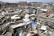
4 Aftermath and Impact
Meteorological Synopsis[]

The NOAA Tornado Outlook for June 24-26
1 Day prior to the outbreak, a storm system came down to the Great Lakes Region, bringing strong wind up to 65 MPH, heavy rain and hail. A 7 Percent Tornado risk was given to Michigan, Ohio, Indiana, Illinois and Kentucky, with a 2 Percent risk introduced to Minnesota, Wisconsin, Iowa, Nebraska, Kansas, Tennessee and
Pennsylvania. 5 Hour, the 7 Percent risk was brought to a 12 Percent risk for Michigan, Ohio, Indiana and Illinois. Wisconsin and Iowa were upgraded to a 5 Percent risk. Day 1 (June 24) Of the Outbreak saw many strong tornadoes, and is considered the most damaging day of the outbreak. Day 2 (June 25) Was more calm, with less tornadoes reported. Day 3, and the final day (June 26) Also saw many strong tornadoes reported. There were also many floods and seiches, including a very destructive seiche in Chicago, and the Mississippi River flooded, with the most destructive flooding being in Clinton, Iowa.
Confirmed Tornadoes[]
| Confirmed Total |
Confirmed EF0 |
Confirmed EF1 |
Confirmed EF2 |
Confirmed EF3 |
Confirmed EF4 |
Confirmed EF5 |
| 326 | 124 | 24 | 104 | 50 | 14 | 13 |
Michigan Confirmed Tornadoes
| Confirmed Total |
Confirmed EF0 |
Confirmed EF1 |
Confirmed EF2 |
Confirmed EF3 |
Confirmed EF4 |
Confirmed EF5 |
| 123 | 52 | 23 | 26 | 13 | 5 | 6 |
Indiana Confirmed Tornadoes
| Confirmed Total |
Confirmed EF0 |
Confirmed EF1 |
Confirmed EF2 |
Confirmed EF3 |
Confirmed EF4 |
Confirmed EF5 |
| 60 | 21 | 0 | 31 | 7 | 0 | 1 |
Ohio Confirmed Tornadoes
| Confirmed Total |
Confirmed EF0 |
Confirmed EF1 |
Confirmed EF2 |
Confirmed EF3 |
Confirmed EF4 |
Confirmed EF5 |
| 45 | 12 | 0 | 18 | 13 | 1 | 1 |
Illinois Confirmed Tornadoes
| Confirmed Total |
Confirmed EF0 |
Confirmed EF1 |
Confirmed EF2 |
Confirmed EF3 |
Confirmed EF4 |
Confirmed EF5 |
| 32 | 23 | 0 | 3 | 3 | 2 | 1 |
Kentucky Confirmed Tornadoes
| Confirmed Total |
Confirmed EF0 |
Confirmed EF1 |
Confirmed EF2 |
Confirmed EF3 |
Confirmed EF4 |
Confirmed EF5 |
| 17 | 6 | 0 | 5 | 5 | 1 | 0 |
Tennessee Confirmed Tornadoes
| Confirmed Total |
Confirmed EF0 |
Confirmed EF1 |
Confirmed EF2 |
Confirmed EF3 |
Confirmed EF4 |
Confirmed EF5 |
| 27 | 2 | 0 | 8 | 9 | 4 | 4 |
Iowa Confirmed Tornadoes
| Confirmed Total |
Confirmed EF0 |
Confirmed EF1 |
Confirmed EF2 |
Confirmed EF3 |
Confirmed EF4 |
Confirmed EF5 |
| 20 | 4 | 0 | 13 | 4 | 1 | 0 |
Pennsylvania
| Confirmed Total |
Confirmed EF0 |
Confirmed EF1 |
Confirmed EF2 |
Confirmed EF3 |
Confirmed EF4 |
Confirmed EF5 |
| 5 | 4 | 1 | 0 | 0 | 0 | 0 |
Notable Tornadoes[]
3.1 Ann Arbor Area Tornadoes[]
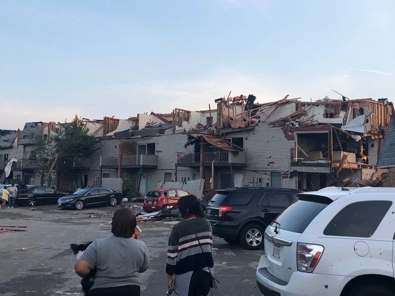
The Ann Arbor Area Tornadoes were 3 EF-5 Tornadoes, in quick succession. Each touching down one after the other, and causing billions in damage and numerous fatalities.
The First Tornado, which formed at 11:42 AM, near the Scio Church and Parker Road Intersection, to the west of Ann Arbor. It quickly strengthened to EF-3 Intensity. At 11:45 the sirens went off, and a Tornado Warning was issued for Washtenaw County. It traveled East, heading towards Ann Arbor. Quickly intensifying, it dealt EF-4 Damage to Houses along Scio Church Road. Traveling along Scio Church Road, it slammed into the Emerson School Building, collapsing all of its walls and roof, burying students and teachers alike inside,
EF-4 Damage in the Eberwhite Neighborhood
causing 3 Deaths and 96 Injuries. It suddenly took a turn north, heading towards I-94, packed with cars. Liberty Athletic Club sustained a direct hit, gaining EF-5 Damage, the first noted along the path. By then, it was over a mile wide, and slammed into the interstate, tossing cars hundreds of yards. As it headed into the Eberwhite Neighborhood, a tornado emergency was issued for Washtenaw County. When it hit the Eberwhite Neighborhood, it took a direct hit to Eberwhite Elementary, where students were hunkered down, dealing EF-3 Damage to the school. Heading slightly Southeast, Pioneer High School got hit by 165 MPH winds, gaining EF-3 Damage. Michigan Stadium was wrecked, and was very damaged. Crisler Center's roof got ripped off, and its wall collapsed. The Tornado was 2.23 Miles wide, Downtown Ann Arbor was slightly damaged, with the Ross School of Business being the most damaged downtown. As it headed into the Burns Park Neighborhood, it slammed into the Elementary School, dealing EF-3 Damage to it, and EF-5 Damage to the houses around it, causing 32 Deaths in the Neighborhood. As it traveled east, it hit Tappan Middle School, and St. Francis School, dealing EF-4 Damage to both, resulting in 12 Student Deaths, and 3 Teacher Deaths. As it traveled east, it hit Gallup Park, killing 2 who were sheltered in a bathroom. As it passed out of Ann Arbor, it hit Concordia University, all the dorms destroyed and the Chapel was severely damaged. Once out of Ann Arbor, it weakened to EF-1 Intensity, hitting a Mobile Home Park in Superior Charter Twp. and severely damaging all the Mobile Homes. Tornado #1 dissipated at 12:21 PM
Tornado #2 formed at 12:49 PM, just north of Dexter, Michigan. It quickly strengthened to an EF-5 tornado in Dexter. It ripped off roofs and then completely destroyed houses. It destroyed Mill Creek Elementary School, killing 3 students
(REWORKING THIS)
The third Tornado formed at 1:22 PM, in a field in Bridgewater as an EF-0 Tornado. 5 Minutes later, however, it was an EF-4 Tornado, traveling Northeast at 40 MPH, hitting houses in Rural Areas of Washtenaw County. As it passed over CornerStone Acre Stables, it collapsed stables, countless horses getting killed. As it came into Ann Arbor, it hit the Municipal Airport, destroying hangars, and the control towers, flipping planes and tearing up asphalt, at EF-5 Intensity. It promptly destroyed the Costco, and a gas station, causing a fiery explosion, as it passed over, killing 10, that were in the Gas Station. As it went through Ann Arbor, it abruptly turned north, passing into the Burns Park Neighborhood, where people were just emerging from basements, killing 42 More, 13 of them Children. Traveling north, it passed into the downtown, causing massive damage to the Law School, and other schools, and then it hit Mott Children's Hospital, causing it to be severely damaged. It passed into North Campus of the University of Michigan, destroying dorms and buildings killing 31 More People, making it the deadliest of the three. Then, as it passed out of Ann Arbor, it dissipated, leaving a clear sky behind.

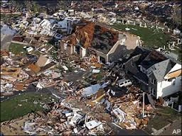
The Ypsilanti Tornado, right outside of Willow Run Airport.
3.2 Ypsilanti Tornado[]
At 3:23 PM, just outside of Willow Run Airport, the Ypsilanti Tornado formed, as a thin, rope EF-3 Tornado. It was rainy, as another storm front had moved in, and the tornado was wrapped in rain, only seen by an Air Traffic Controller, who immediately phoned it in, and the tornado sirens started up. It traveled into Willow Run Airport, only just missing the control tower, and passing into Ypsilanti, as an EF-4 Tornado. It hit a mobile home park, destroying all of them immediately, killing 13 People. It strengthened to a high end EF-4 Tornado, with windspeeds of 195 MPH, and was given an EF-4 Rating, although some debate it could have been a low end EF-5. It traveled North, and barely missed Ann Arbor, which had just been hit with 3 EF-5 Tornadoes. It dissipated in a field in Superior Charter Twp at 3:41
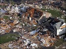
3.3 Battle Creek-Albion-Parma-Woodville-Jackson Tornado[]
At 12:21 PM, an elephant trunk Tornado formed inside Fort Custer Recreation Area as a weak EF-1 Tornado. Quickly traveling into Battle Creek, it hit it as an EF-3 Tornado, and hit Battle Creek Executive Airport, destroying the hangar and throwing private planes into the air. It passed through a neighborhood, destroying houses and a church at EF-5 Intensity, killing 6. As it passed into the downtown, Kellogg Arena was severely damaged, then it turned east, slamming into a mobile home park, destroying it. As it passed over open land, it hit an Amtrak Train, throwing it up into the air, then back down into the ground, killing 19 people. It entered Albion, passing through it in 3 Minutes, at EF-5 Intensity. 95% Of Albion was leveled, and 56 People were

Aerial Tornado Damage in Parma
killed. 8 Minutes after flattening Albion, it hit Parma, destroying the Elementary School, killing 3 People, and destroying all the houses in Parma. As it passed out of Parma, it came into Woodville, flattening a subdivision with winds of over 304 MPH, then passed into Jackson, flattening yet another Subdivision, and then, turning North, it hit Jackson County Airport, destroying it, and ripping up asphalt and tossing planes into surrounding neighborhoods, as it passed through Downtown, it flattened every building in the Downtown, and hit Northeast Jackson Elementary, giving it EF-4 Damage, then, it looped backwards, heading towards Jackson

The Walmart Superstore in Jackson
County Airport, and Flattening a Walmart Superstore, then, it headed east, hitting the Henry Ford Allegiance Health Center, severely damaging the main building, and destroying the Women's Health Services Building and the ER. As it passed out of Jackson, it flattened a subdivision, killing 4 People, then passed onto I-94, as an EF-1 Tornado, then, as suddenly as it had formed, it disappeared.
3.4 Chesterton-Porter-Michigan City-New Buffalo-Baroda-Shoreham-St. Joseph-Benton Harbor Tornado[]

Damage to a house in Chesterton
At 9:21 AM, the Tornado formed as a weak EF-0 Tornado on Lake Michigan, then came onshore in Porter, dealing minor EF-1 damage to some houses on the beach. As it traveled inland, it gathered strength, throwing a car on Roskin Road into a dune, killing 2 people. It entered Porter as a High End EF-2 Elephant Trunk Tornado. It damaged 21 structures in Porter, then entered Chesterton as a low end EF-3, severely damaging 121 Structures, killing 3, and flipping a train car. Wrapped in rain, it exited Chesterton, headed slightly Northeast. As it traveled towards Michigan City, it strengthened to EF-4 Intensity, and had grown over 1.6 miles wide, and a tornado emergency was issued for LaPorte County. As it entered LaPorte County, it flattened a subdivision, with all structures suffering EF-4 damage, killing 9 People. Then it traveled on, Knapp Elementary School sustaining a direct hit, killing 2, and dealing EF-4 damage to it. Additionally, Indiana State Prison was also hit, getting EF-3 damage, killing 1 prisoner, who was against a first floor wall, when it collapsed. As it traveled further into Michigan City, it flattened over 160 blocks of houses, destroying more than 700 houses, killing 42 people, and flattening Marquette High School. When it passed into downtown Michigan City, it destroyed the LaPorte County YMCA, in the downtown, it flattened 211 Structres, killing 11 people, then, as it passed out of the downtown, it flattened another 80 blocks of neighborhood, and, as it passed over a cargo train loading area, it flung 9 train cars into the air, then, as they fell down, they crushed 12 houses, killing 2, and causing a massive explosion, further killing another 23 people. When it passed out of Michigan City, it had windspeeds of over 210 MPH, and dealing EF-5 damage

New Buffalo after the Tornado.
to a house in a field, making it qualify as an EF-5 tornado. As it passed into Michigan, it passed over open fields, not doing any. structural damage. Once it passed into Michigan, a Tornado Emergency was issued for Berrien County, and a Tornado Watch was issued for Van Buren County. Once it passed into Berrien County, it grew to over 2.1 miles wide, set to swallow the town of New Buffalo. As it passed into New Buffalo, it had windspeeds of 253 MPH. In New Buffalo, over 50 structures had EF-5 damage, sites swept clean. As it hit the Marina, it threw boats over 500 feet into the air. Afterwards, boats were found more than 1.5 miles inland, tossed by the tornado. All of New Buffalo was leveled. After exiting New Buffalo, it headed inland, towards Baroda. At that time a satellite tornado had spawned, at EF-2 intensity, causing minor damage to some farms. As it entered Baroda, as an EF-5 Tornado, with windspeeds of 232 MPH. Baroda,

Baroda Mobile Home damage.
being a town of mostly Mobile Homes, was completely destroyed, and nothing was left of Baroda. 879 people were killed, as they had no secure place to go to. Virtually wiping out the town of Baroda, killing 876 people out of it’s 881 person population. Later, the two survivors in Baroda died of injuries, wiping out Baroda for good. Then the tornado passed out of Baroda, it started heading Northwest, towards the town of Shoreham. Traveling at over 50 MPH, it reached the town of Shoreham, weakened to an EF-4 with 175 MPH windspeeds. Once it reached Shoreham, it flattened a row of Beach Houses, and a subdivision, killing 14 people, all in one Condo. As the tornado rolled through Shoreham, it further weakened to an EF-3
Damage to a condo in St. Joseph.
tornado, at 0.89 miles wide. As it rolled through the Marina, it flipped boats, and threw them hundreds of meters inland. Many structures in Shoreham were damaged, the total death toll there was 39 People. As it passed out of Shoreham, along the beach, 3 People were killed by the winds out on Lake Michigan, that overturned their boat. Then St. Joseph got hit, with a re-strengthened low end EF-5 Tornado, with winds of 205 MPH, that was 0.74 miles wide. First, it completely destroyed St. Joseph High School, killing 1 person, then flattened 30 Blocks of houses, killing another 21 people. As it passed downtown, it dealt EF-5 damage to 13 structures, killing 7 people. Then, it flattened Berrien County Courthouse, killing 3 People as the roof and walls collapsed. As it crossed the St. Joseph River, separating St. Joseph and Benton Harbor, it weakened to an EF-3 tornado, that was 0.43 miles wide. As it hit Benton Harbor, it further weakened to an EF-1 tornado, damaging Benton Harbor High School. Then, it became an EF-0 tornado, and dissipated on the runway of Ross Field- Twin Cities Airport. This became the deadliest tornado in the USA, and the deadliest since the Daulatpur-Saturia tornado, being the 2nd deadliest tornado in the world, with over 1,000 deaths.
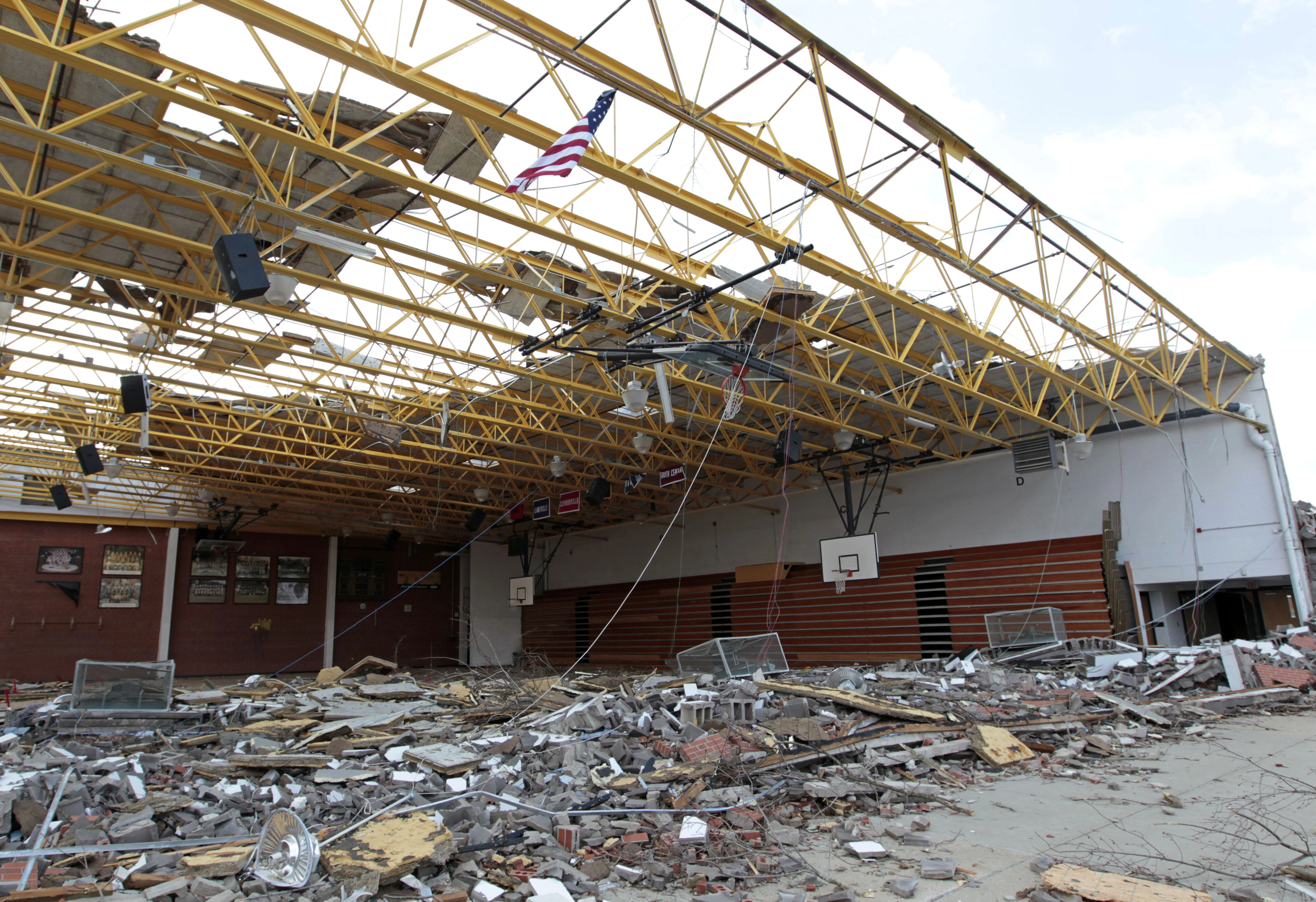
3.5 Holland-Zeeland-Hudsonville-Grandville-Grand Rapids Tornado[]
At 12:31 PM, in Holland, Michigan, above Lake Macatawa, a thin funnel cloud hovered above the surface. 2 hours prior, a Tornado Watch was issued for Ottawa and Allegan Counties, and at 12:32, a Tornado Warning was issued for Ottawa and Allegan Counties. At 12:23, the funnel cloud touched down on the shore of Lake

Damage to the Black River Public School Gymnasium.
Macatawa, as a weak EF-0 Tornado, and it started to travel into Holland. As it traveled inland, it strengthened to an EF-1 tornado, and did minor damage to 124 Structures. As it traveled further into Holland, it strengthened to an EF-3, and grew to 0.97 Miles wide. When it hit Black River Public School, it caused EF-3 Damage to it, killing 4 People, then, as it passed into the Northeastern part of Holland, it officially became an EF-4 Tornado, flattening a subdivision, killing 5 people. Then, as it passed into Zeeland. On one Cul-de-Sac, 31 people were killed, when their houses caved in on them. As it hit Cityside Middle School, it suffered EF-4 damage, killing 2 people. Then, it hit another neighborhood, with windspeeds of 195 MPH, flattening 20 blocks of neighborhood in Zeeland, before hitting Spectrum Health Zeeland Community Hospital, causing the second and third floors to

A car on I96, where 1 person was killed.
collapse, and tearing off the ceiling of the 1st, killing 21 patients and 3 medical staff. Then, as it tracked Northeast on I96, it flipped cars and threw them into the air, killing 6 people, also, the torrential rain caused flooding in Western Michigan. As the tornado tracked into Hudsonville, it flattened a subdivision, killing 13 people, dealing EF-4 damage to 99 structures, and EF-3 Damage to 21 structures. As it passed further into Hudsonville, it destroyed Hudsonville Christian School, causing EF-4 damage to be done to it. When it passed into Grandville, it weakened to an EF-3 Tornado as it hit Grandville High School. It passed through Grandville relatively quickly, in 2 minutes, causing severe damage to over 2000 structures in Grandville, killing


Hail Damage to a Mobile Home in Grand Rapids.
1 person. The tornado passed north out of Grandville, into Millennium Park, causing mass damage to trees, and then, as it passed into Grand Rapids, it became an EF-2 Tornado. It hit John Ball Aquarium, causing roof damage and damage to trees. As it passed into a densely populated neighborhood, it caused damage to 211 houses, and damaged trees in the neighboorhood, causing numerous injuries. As it passed over the Grand River, it weakened to an EF-0 Tornado, then dissipated over Helen DeVos Children's Hospital.
3.6 Owosso Area Tornadoes[]
At 9:21 AM, outside of Owosso, Michigan, a thin rope tornado formed (Tornado #1). At 9:22 The sirens went off in Owosso and Corunna and all over Shiawassee County. The tornado moved away from Owosso as an EF-0 Tornado. As it crossed the Shiawassee River, it strengthened to an EF-1 tornado, then turned towards Owosso. As it headed towards Owosso, it hit DeVries Nature Conservancy, causing roof and window damage, before hitting a subdivision outside of Owosso. As it hit the subdivision, it strengthened to an EF-2 tornado, causing roof, wall and window damage to 23 houses, causing 3 injuries. Once it passed out of the subdivision, it strengthened to a high end EF-3 tornado. The tornado passed into Owosso, severely damaging Owosso High School, before passing into a populated
Aerial damage in Owosso

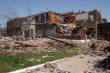
Damage to Owosso High School
neighborhood. In the Neighborhood, it strengthened to an EF-4 Tornado, destroying 42 houses and severely damaging 133 houses, killing 2 people. Passing out of the Neighborhood, it hit a Rail Yard, flinging 3 train cars into the Shiawassee River, mangling the cars. Out of the rail yard, it hit Owosso Community Airport, destroying the hangar and throwing planes into the air. Once it passed out of the airport, it hit another Neighborhood, destroying another 62 houses, before barreling out of Owosso, and dissipating in a field as an EF-0 Tornado, at 9:56

EF-2 damage to a house near the Shiawassee River
Tornado #2 formed at 11:02 AM, outside of Corunna, again, the sirens went off in Shiawassee County, where a tornado had already devastated Owossso 1 hour prior. The Tornado headed west at 50 MPH, strengthening to an EF-2 Tornado, it plowed through a neighborhood by the Shiawassee River, severely damaging 42 structures as a rope EF-3 tornado with windspeeds of 152 miles an hour. Turning south, it crossed the Shiawassee River, it turned east again, heading on East Main Street, it destroyed 52 businesses as a high end EF-3 tornado, killing 3 people before passing into the eastern part of residential Owosso. In eastern
Owosso, 122 structures get severely damaged by 155 MPH winds, killing 1 person. Passing into Downtown, it destroyed 23 structures, before stripping Owosso Middle School of its roof and exterior walls, as it headed Northwest. Heading Northwest, it destroyed another 142 structures, before severely damaging Memorial Healthcare Hospital, killing 2 patients, who were on ventilators. As it crossed the Shiawassee River a second time, it weakened to an EF-2 tornado, as it passed into another neighborhood, damaging 99 structures, before passing out of Owosso at EF-1 strength, with winds of 101 MPH. Once out of Owosso, the tornado went to EF-0 Strength, lasting for another 11 minutes before dissipating at 11:31
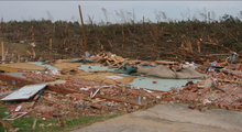
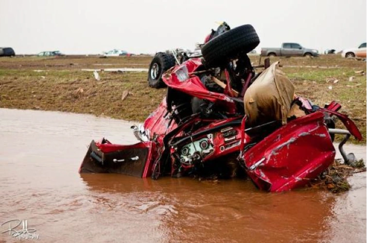
3.7 Peru-Mendota Tornado[]
At 4:53 PM CST, a Funnel Cloud formed above an Island on the Illinois River, causing the sirens to go off at 4:54, and at 4:55, the funnel cloud touched down, and stayed in place for 4 minutes, strengthening to an EF-2 tornado. At 4:59, it started moving towards Peru, crossing the Illinois River, it strengthened to an EF-3 tornado. At 5:01, it crossed the shores of the Peru side of the Illinois River, and, passing into Peru, it grew to

Northview Elementary after the tornado
1 mile wide, destroying a subdivision, and swallowing 1/3 of Peru, it destroyed 523 Structures, killing 21 people. As the tornado passed into Centennial Park, it uprooted trees and caused major ground scouring, then it hit Northview Elementary, where students had just gotten out of school, 1 janitor was killed in Northview as the walls collapsed. As it hit a subdivision, it reached EF-5 intensity, with 241 MPH winds, sweeping away 21 houses in the subdivision, killing 3 people, before passing out of Peru. Crossing I-80, the tornado threw countless cars into the air, killing 2 people. As the tornado traveled over fields, it destroyed 11 farmhouses, killing 6 people in one farmhouse, as the roof collapsed on them. As it neared Mendota, the tornado weakened to an EF-3 wedge Tornado. The tornado entered Mendota as an EF-2 Tornado, damaging 23 structures before dissipating in downtown Mendota.
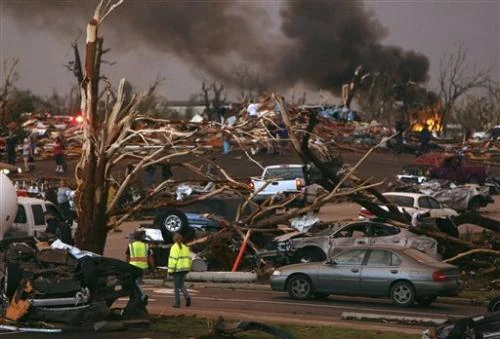
3.8 Chicago Area Tornadoes[]
At 6:21 AM, on June 25th, a waterspout formed off of Chicago, with windspeeds of 101 MPH, causing waves of over 2 feet high to wash up against the shore. The tornado strengthened over the water, getting wind speeds over 145 MPH, and moved closer to shore. As the tornado moved closer to shore, strengthening to a tornado with winds of 184 MPH, it pushed water forward, causing a seiche 15


Damage to a skyscraper in Downtown Chicago, where 11 people were killed, as they were blown out of their offices.
feet high, pushing into Chicago, with the downtown getting the brunt of the damage, causing 13 pedestrian deaths, who were watching the waterspout. In Downtown, over 20.3 Million Dollars in damage were caused when the water broke windows and pushed doors open, causing interior damage. 2 more people were killed when they drowned inside the lobby of Willis Tower, then the tornado made landfall, in downtown Chicago, as an EF-4 tornado, breaking windows in almost every building in Downtown, at then, the tornado was 1.98 Miles wide, and it killed 34 more people, in their offices. The tornado destroyed some 6 story buildings downtown, with 195 MPH Winds, further killing 21 people. The tornado moved out of downtown, flipping and throwing cars more than 200 feet into the air, as it destroyed a parking garage. Once the tornado came out of downtown, it passed into a neighborhood. The tornado weakened to an EF-3 tornado, as passing through the downtown had leeched its strength. The tornado severely damaged 1023 structures, killing 29 people and ripped the roof off of Prairie Oak School, causing 3 injuries, then, as quickly as it has formed, the tornado dissipated. The seiche continued to travel into Chicago, eventually reaching 2.93 Miles into Chicago, causing 21.93 Million dollars in damage in total.
A second tornado formed in the residential area of Chicago, as an EF-2 Tornado, roofs got ripped off and walls collapsed. It grew to 0.53 Miles wide, severely damaging 1021 Houses before roping out just outside of Downtown Chicago.
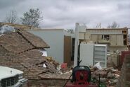
3.9 Kettering-Dayton-Springfield-Marysville-Marion-Galion-Mansfield Tornado[]
At 3:21 PM EST, a funnel cloud formed over the Golf Course in Kettering. Instantaneously, the sirens went off. At 3:22 PM, the funnel cloud made contact with the ground, at EF-0 strength, it hit 4 houses nestled in the Golf Course. It quickly strengthened to an EF-3 Tornado, hitting a subdivision, severely damaging 103 Houses. It then strengthened to an EF-4, hitting Miami Valley School, dealing EF-3


Damage to a house in the first subdivision affected.
damage to it, ripping off the roof and destroying exterior walls. Then, it looked around, heading back towards the Golf Course, striking the area of houses nestled in the Gold Course, that had been affected 9 minutes earlier. Heading Northwest, it headed towards Kettering Medical Center. As it hit the Kettering Medical Center, it strengthened to an EF-5 with winds of 331 MPH, literally destroying the hospital, reducing it to complete rubble, killing 143 patients, and 11 doctors and nurses. Then the tornado turned due north, towards Dayton. It destroyed 2114 Houses, killing 21 more people, as it grew to 2.1 Miles wide. As it hit Dayton, it swallowed the University of Dayton Campus, effectively destroying or severely damaging all the buildings, as the tornado grew to a 2.3 Mile wide tornado with 353 MPH winds, killing 34 people. Hitting the Miami Valley Hospital, it slightly weakened to a tornado with 301 MPH winds, still ripping off the roof and severely damaging the hospital, killing 1 patient with COVID-19 on a ventilator. It passed into the downtown, severely damaging 123 buildings before passing out of Dayton. The tornado passed over open fields for a while, damaging 3 structures, before passing into Springfield. In Springfield, the tornado passed into a subdivision, destroying 111 houses, causing EF-5 Damage to 23 houses. As the tornado headed into central Springfield, it hit Hayward Middle School, destroying it, killing 1 student, and injuring 24 students, and 3 teachers. The tornado tracked into a heavily populated area, destroying 2143 Houses, and killing 8 people. When it


EF-2 damage to a house in Springfield.
hit the Springfield YMCA, it was reduced to rubble. As it passed on multiple overpasses, throwing hundreds cars into the air, and killing 11 people. Then it started to head Northwest, towards WittenBerg University. When it hit, multiple college buildings were destroyed, as it tracked towards Mercy Imaging Hospital Springfield. As it hit the hospital, gusts of winds over 350 MPH were constantly observed. The hospital was destroyed, killing 96 people. Then, it tracked out of Springfield. For a while, the tornado passed over open fields, killing farm animals, and 1 farmer who was in his tractor as the Rain Wrapped Tornado flipped his tractor. The tornado passed into Marysville as a weakened EF-4 Tornado, and at 2.96 Miles Wide, it became the widest tornado on record, swallowing Marysville. The Women’s Prison was obliterated, killing 11 prisoners, and 13 guards. 32 people were killed in Marysville as the tornado ripped apart houses and businesses. The tornado passed over more open land, as it went toward Marion. The tornado headed slightly Northeast, and scraped the Northeastern side of Marion, damaging the hospital and 211 houses. The tornado headed towards the town of Galion. By that time, it had weakened to an EF-3 tornado, severely damaging 891 Houses, and killing 1 man. The tornado tracked into Mansfield as an EF-1 tornado, roping out at 5:22 PM.
3.10 Columbus Area Tornadoes[]
The first of many Tornadoes in the Columbus formed at 9:01 AM, as an EF-1 tornado, just outside of Downtown Columbus. The tornado strengthened to an EF-3 tornado at 9:09 AM, severely damaging


Houses in Columbus that were damaged.
many houses. It stayed at EF-3 Intensity as it passed through the downtown, but passing through the downtown greatly weakened it, and shortly after, it dissipated.
The second (Major) Tornado in Columbus made contact with the ground at 9:22 AM, as an EF-2 tornado. It traveled through neighborhoods, then strengthened to an EF-4 Tornado. It completely destroyed 3391 ho
THIS IS WIP, PLS DO NOT EDIT