| EF4 tornado | |
|---|---|
 Tornado viewed from the south in New Iberia. | |
| Date | November 21, 2038 |
| Times | 1307-1354 |
| Touchdown location | 1:07 PM CDT |
| Highest winds |
175 mph (estimated) |
| Injuries | 523 |
| Fatalities | 44 |
| Damage | $1.4 billion (2038 USD) |
| Areas affected | Abbeville & New Iberia, Louisiana suburbs |
| Part of the 2038 Tornado Season | |
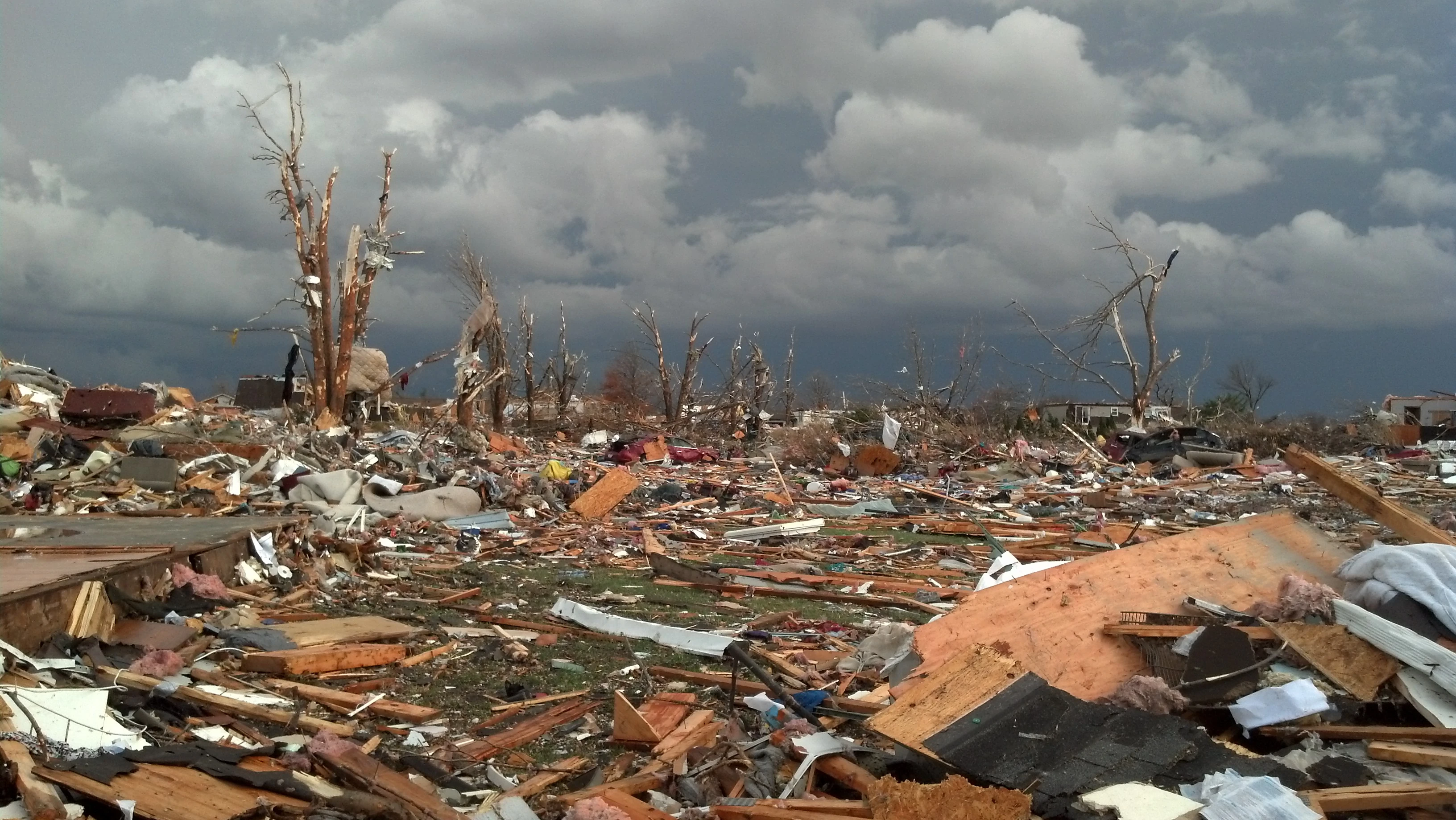
The 2038 Abbeville-New Iberia, Louisiana tornado was a violent and deadly EF4 tornado which struck areas of south-central Louisiana in the early afternoon of Sunday, November 21, 2038. The tornado left a 42.75-mile path and remained on the ground for 47 minutes; reaching EF4 strength in the city of Abbeville and again near New Iberia. The tornado was by far the deadliest in the year 2038 as well as the deadliest in the state of Louisiana since 1971, causing a total of 44 deaths and 523 injuries, mainly within the city of Abbeville itself. The tornado's most intense damage also occurred in and near Abbeville; with 37% of buildings in the city being severely damaged or completely destroyed.
16 of the tornado's 44 fatalities occurred in vehicles which were tossed from roads. The tornado's high death toll was attributed in part to its unusual appearance, manifesting as a "blob-shaped", mostly transparent funnel while it cut through Abbeville. Due to the transparent condensation funnel and relatively little visible rotation, many residents of Abbeville mistook the tornado for a rain shaft. Later in its path, the tornado became more clearly defined and surrounded by low-hanging scud clouds, and as a result significantly fewer deaths occurred in New Iberia despite the tornado being of similar intensity near the city as it was in Abbeville.
The tornado was part of Tornado outbreak of November 21, 2038 which affedted most of Louisiana as well as parts of southern Arkansas and eastern Texas. The outbreak lasted for roughly 18 hours and produced a total of 32 tornadoes, including two which were rated EF3 in addition to the EF4 Abbeville-New Iberia tornado. All but four of the 48 tornado-related fatalities of the outbreak were caused by this single tornado, which was infamously described as "Moore in the south" in a Weather Channel special.
The tornado's occurrence one year and seven months after the 2037 Super Outbreak prompted more serious regional and federal consideration of "the possibility of a rise in the number of violent tornadoes", and federal investment in stronger purpose-built community storm shelters was called for by the Louisiana state government.
Meteorological synopsis[]

1630z tornadic risk outlook on November 21.
Conditions on November 21 were noted as being similar to December 23, 2015 and January 11, 2024. A strong upper-level shortwave trough was established through the Central Plains states and an associated north-to-south-oriented cold front extended through the far western Midwest into the Dixie Alley region. CAPE in the Dixie Alley area on November 21 was around 3,500 J/kg, and the Storm Prediction Center issued a moderate risk for Louisiana, Arkansas, western Tennessee, and western Mississippi based primarily on a risk of large hail, with a 10% risk of tornadoes throughout the western Dixie Alley region. While conditions favoured the development of an intense squall line rather than discrete supercells, an intense upper-level jet stream ahead ahead of the cold front, along with strong directional shear and ample moisture return prompted the Storm Prediction Center added a small 15% hatched risk of tornadoes for southern Louisiana in its 1630 UTC outlook update.
At 9:30 AM, a rare PDS severe thunderstorm watch had been issued for most of southern Louisiana including Vermilion Parish, Iberia Parish, and Iberville Parish, noting a 90% risk of damaging wind with an 80% risk of hurricane-force winds, as well as an 85% risk of damaging hail and a 70% risk of hail more than two inches across. By 11:00 AM, the watch was replaced by a tornado watch with a 60% risk of two or more tornadoes and a 30% risk of one or more strong (EF2+) tornadoes.
Small clusters of thunderstorms including a few supercells developed in the morning hours of November 21, but had organized into a squall line by 9:00 AM CST. The system moved east-northeastward from far eastern Texas across Louisiana and southern Arkansas, producing torrential rain and hail up to 2.5 inches across. The first tornadoes produced by the squall line were twin EF0 tornadoes which caused minor damage near Jasper, Texas. At 11:30 AM, hail up to 4 inches across fell on the community of Bell City, Louisiana, killing livestock and injuring three people. A large funnel cloud was observed developing to the east of Bell City, but did not touch down. One non-tornadic death was reported in rural Calcasieu Parish near Hayes, as a car was pushed from a road into a ravine by a straight-line wind gust estimated to have reached speeds of 95 miles per hour or higher.
At 12:41 PM, a severe thunderstorm warning was issued for Vermilion Parish and Iberia Parish, and extended to Iberville Parish ten minutes later as the squall line approached. At 12:56 PM, an area of tightening rotation was observed over Grand Lake, leading to the issuance of a tornado warning for Vermilion Parish. Storm spotters observed a nebulous and partially rain-wrapped funnel that extended towards the ground, apparently dissipated, and began to extend again repeatedly for several minutes before the tornado fully formed.
Tornado summary[]
The tornado touched down at 1:07 PM CST to the south of Spencer Road in rural Vermilion Parish. Several trees were toppled at EF1 strength shortly after the tornado formed, and power poles along Spencer Road were downed. After crossing a narrow ravine, the tornado damaged the roofs of several rural frame houses and completely removed roofs from barns and tool sheds. Continuing through empty fields, the tornado caused little damage over the next two miles of its path. A few small sheds and outbuildings were severely damaged or destroyed before the next substantial damage occurred as the tornado crossed Tony Road, where a farmhouse lost all but a small portion of its roofing, and small, shallow-rooted trees nearby were toppled. An SUV parked nearby and a small parked tractor were blown over as well. To the east, the tornado partially demolished a storage barn and damaged a grain silo; damage in the area was rated high-end EF1.
The tornado continued to cause high-end EF1 damage to scattered barns and outbuildings as it continued over two miles of mainly empty fields before reaching EF2 strength near Len Guidry Road, where a tractor shed was demolished and a chicken house was mostly leveled. Past this point, the tornado crossed over an apple orchard, uprooting and snapping hundreds of small trees in its path as well as pushing over steel wire fencing. A cluster of frame houses on Emick Road to the east was struck at EF2 strength; all houses lost most or all of their roofing, and a portion of a second-floor wall at one was demolished. A large elm tree nearby was snapped in half as well. The tornado weakened to EF1 strength near Cemetery Road, where roofing was completely removed from barns and the Majestic Oaks Lodge sustained moderate roof damage. Reintensifying to EF2 strength, the tornado passed over a row of spruce trees which were toppled and snapped, before rolling a minivan off of William Road, severely injuring the driver. The tornado then weakened again to EF1 strength as it passed over a farm on the far side of William Road, stripping away the roofing from barns and blowing over an oak tree which fell on the farmhouse, injuring two residents. A small group of houses along Louisiana Route 3093 sustained high-end EF2 damage, with one older, poorly-constructed house being completely demolished, and two others losing their roofing, and, in one case, one exterior wall. One person was killed at this location, and three others were injured.
High-end EF2 damage to trees and outbuildings continued for the next half-mile of the tornado's path. The first instance of EF3 damage occurred near the intersection of Juniper and Crabapple Road, where two frame houses were mostly demolished, with only interior walls left standing, and a barn and a steel storage shed nearby were leveled. To the east, a large oak tree was uprooted and a tractor tossed 60 yards before the tornado's path shifted significantly to the northeast. The tornado crossed Louisiana Route 35 to the south of Kaplan at 1:17 PM at mid-range EF3 strength, tossing a minivan and an SUV 80 yards from the highway and killing both drivers. Along the edge of the highway, several large warehouses sustained severe damage and nearby frame houses were destroyed, resulting in several injuries. After crossing another stretch of empty fields, the tornado leveled a tractor shed and a warehouse on Klaby Meaux Road, demolished three split-level houses, removed the roofs from two others, tossed parked cars and a trailer up to 110 yards, and partially debarked several trees. One person was killed on Klaby Meaux Road and six others were injured. Damage in the area was officially rated mid-range EF3, but one damage survey concluded low-end EF4 damage in the area. As the tornado's path paralleled the Bull Moose Canal, a row of houses to the north of the canal on Hargrave Line was mostly demolished, with two being completely leveled at high-end EF3 intensity.
The tornado continued over empty fields for the next two miles of its path, causing relatively little damage, but remained intense; as it crossed through rural areas, the tornado more than doubled its width, reaching 500 yards wide before striking a farming neighbourhood to the west of Abbeville at 1:22 PM. By this time, the tornado had become violent, leveling frame and split-level houses in its path, debarking trees, and tossing parked cars up to 140 yards. Four people were killed in this subdivision and over 70 were injured. Among the deaths were a mother and a ten year old boy who attempted to shelter inside a drainage ditch, but were hit and killed by debris from nearby houses. The tornado then debarked most of the trees in a small grove to the east of the subdivision in typical EF4 fashion. As the tornado approached the city of Abbeville itself, storm chasers photographed a nebulous, bubble-like funnel with multiple suction vortices within the main funnel. The rotation of the visible funnel was minimal, and despite the issuance of a PDS tornado warning for Abbeville, many in the tornado's path mistook the funnel for a rain shaft.
EF4 damage in western Abbeville.
The tornado entered the Abbeville city limits at 1:25 PM at EF4 strength, first striking the Abbeville RV Park, where hundreds of RVs were tossed up to 120 yards, and mobile homes were completely swept away with almost no debris remaining where they had once stood. The tornado then continued northeast to Park Avenue, demolishing or leveling numerous well-constructed houses in its path, tossing parked cars more than 180 yards through the air, and debarking several trees in its path. Sections of loose, cracked pavement were scoured from Thomas Street as well. As the tornado crossed Park Avenue, several motorists were caught and killed when their cars were tossed from the road. The Vermilion Catholic High School was mostly demolished, with only a few interior walls still standing, while the neigbouring Mt. Carmel Elementary School was severely damaged, losing almost all of its roofing and all exterior walls.


Low-end EF4 damage in eastern Abbeville
In the east side of the city, more frame houses and several small stores including a Dollar General and the RiverFront restaurant were demolished or completely flattened. As the tornado crossed the Highway 14 Bypass Bridge, an SUV and a minivan were tossed from the bridge into the Coulee Kenny River. The driver of the minivan was killed, while the driver and passenger of the SUV were critically injured. Several more businesses on the eastern side of the river were leveled, including an Advance Auto Parts, a McDonald's restaurant, and the Nu-Tek auto repair shop. The tornado then continued over residential areas, completely demolishing many large and well-constructed split-level houses before continuing east and out of the city. A total of 32 people were killed in Abbeville, mostly on and near State Street North, and the high death toll was attributed to the very unusual appearance of the condensation funnel leading many residents to not recognize the tornado. Damage in Abbeville was rated low-end EF4, with estimated wind speeds of 175 miles per hour.
The tornado continued to the south of Albert Road while weakening to EF3 strength. Frame houses outside the Abbeville city limits were demolished or mostly leveled, and several more cars were tossed from roads, leading to three additional deaths. Continuing over more rural areas, the tornado widened to nearly 1.5 miles in width while developing a more visible, irregular condensation funnel surrounded by low-hanging scud cloud. EF2 to EF3-level damage was observed as the tornado passed over several farms in rural Iberia Parish, removing the roofing from barns and farmhouses, tossing several parked cars and tractors up to 95 yards, and causing two human fatalities as well as killing dozens of livestock. The tornado then crossed over Lake Peigneur as a large waterspout, then leveled a row of small cottages on the eastern shore of the lake at EF3 strength.


Tornado in rural Iberia Parish.
EF2 to low-end EF3-level damage occurred along and to the north of Jefferson Island Road, where houses were partially demolished, parked cars flipped, and trees toppled and denuded. The tornado weakened further to mid-range EF2 strength as it continued east through rural Iberia Parish, snapping trees and power poles along the edge of rural dirt roads. Low-end EF3 damage occurred in the small community of Charlotte, where several frame houses were demolished and the Jefferson Island Elementary School lost most of its roofing. The tornado was visible as a ragged funnel as it approached New Iberia; the majority of the city's residents were able to take shelter before the tornado's arrival, due to the early issuance of a tornado warning for New Iberia.

Low-end EF4 damage in New Iberia.
New Iberia was struck at 1:48 pm CDT. Shortly before entering the city limits, the tornado dramatically reintensified, reaching EF4 strength for a second time. As the tornado cut through the northern edge of New Iberia, well-constructed frame houses and split-level brick houses in its path were completely leveled, with the most intense damage being on and near North Landry Drive. A seafood restaurant was demolished as well, with cars in its parking lot being tossed up to 125 yards, and trees were mostly or entirely debarked. Eight people were killed in New Iberia, and hundreds more were severely or critically injured. Damage in New Iberia was rated low-end EF4 with wind speeds estimated at 170 miles per hour. As a result of early warning and a much more distinct condensation funnel, the death toll in New Iberia was over three times less than in Abbeville.
The tornado then weakened rapidly as it continued east, causing low-end to mid-range EF3 damage in the town of Morbihan, where frame houses were partially or mostly demolished and trees were snapped and uprooted. Continuing over forested areas of Iberville Parish, the tornado caused EF2-level tree damage and flipped a moving car off of a road and into a drainage ditch, killing the driver. Around this point, the visible condensation funnel became nebulous and transparent again, while narrowing and taking on a rough barrel shape. The tornado weakened to EF0 strength by 1:52 pm, and dissipated completely near the shore of Lake Fausse Pointe at 1:54 pm.