The Early October 2040 Tornado Outbreak was a very violent tornado outbreak which spawned 44 tornadoes, all rated EF2 or higher.
Synopsis[]

The Convective outlook issued by the Storm Prediction Center for October 1, 2040.
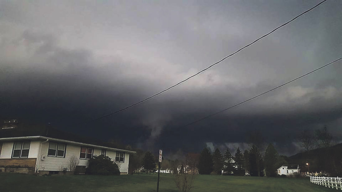
The final week of September started out as a peaceful week across most of the US. The most recent event had occured 3 weeks earlier, when widespread damaging winds struck the Southwest. There was a small possibility of a storms from early Monday morning into Wednesday, mostly non-severe. However storms began to become more likely as the week started to come to a close. On Saturday, September 29, the day 3 convective outlook from the Storm Prediction Center showed a marginal risk extending from Eastern New Mexico extending to Central Nebraska. A Slight risk was in effect for parts of Oklahoma. By Sunday most of the midwest was under a slight risk, with an Enhanced risk in effect for parts of the Texas panhandle. By mid afternoon Sunday, a low pressure system was swinging down through Far western Michigan, and across the midwest and southeastern states before twisting Northeast and shooting offshore near the New England Coast. Meanwhile, As sun started to go down, an upper level trough was Expanding over the Northwest territories of Canada, and started dipping to the south as the time neared Midnight. Just after 11:00 PM, a cluster of non severe storms began to develop just North of the Canada border as the front pushed into the warm sector. Then, as the storms dropped past the border, activity rapidly picked up and intensified.
| Confirmed Total |
Confirmed EF0 |
Confirmed EF1 |
Confirmed EF2 |
Confirmed EF3 |
Confirmed EF4 |
Confirmed EF5 |
| 44 | 0 | 0 | 1 | 30 | 11 | 2 |
October 1 Event[]
Early Morning derecho[]
Just after 1 in the morning, the cluster of storms came together and formed into more organized and dangerous storms, Severe Thunderstorm watches and Tornado watches were already in effect. The storm was now a very strong, fast moving, and extremely dangerous windstorm know as a Derecho. These are very strong wind storms which produce very strong winds. Meanwhile, the system started to gain strength as it moved into Oklahoma. A wind gust of 128 MPH was recorded at the Oklahoma City Airport, where a man was killed when debris from an airplane hit him on the head. Another fatality was reported in the downtown area. The cause of death is unknown. The Storm continued through the suburbs, causing winds over 100 mph, ripping apart roofs like paper and twisting trees from the ground and debarking them like pencils. The storm slowly died out as it moved toward the southeast where it slowly decayed into stray convection over the costal waters of Alabama as it approached daybreak.
Tornado Event[]
As the leftover convection from the derecho began to re-intensify, storms quickly re-developed into supercells. Outside the system, an area of outflow from costal Alabama to Kansas allowed more storms to develop over the area. 5 tornadoes developed, 1 EF5 and 4 EF4s.
Stillwater, Oklahoma[]
| EF5 tornado (NWS) | |||
|---|---|---|---|
| |||
| Duration | 11:39 AM – 12:12 PM | ||
| Intensity | 455 km/h (280 mph) (1-min) | ||

The strongest tornado of the Outbreak, the tornado was spotted by several residents in and outside of Stillwater. The tornado was large and dangerous from the start, and was already producing EF5 damage in less than a minute. The tornado ripped through cornfields grinding crops to shreds and leaving a large mile wide scar through the ground. Only 10 People died, which was quite lucky considering the amount of damage this tornado did.
El Paso, Texas[]
| EF4 tornado (NWS) | |||
|---|---|---|---|
| |||
| Duration | 12:15 PM – 12:29 PM | ||
| Intensity | 290 km/h (180 mph) (1-min) | ||
This tornado formed over the suburbs of El Paso as a weak, rain wrapped tornado. The tornado was never seen at it's peak strength because it was rain wrapped at it's peak. It is unknown whether or not it was a multi vortex or a single tornado. All that is known is that it produced major damage. As the tornado roared through downtown, it snapped buildings from their foundations and caused some to topple to the ground. 45 were killed, making it the second deadliest of the outbreak.
Midkiff, Texas[]
| EF4 tornado (NWS) | |||
|---|---|---|---|
| |||
| Duration | 12:47 PM – 1:19 PM | ||
| Intensity | 315 km/h (195 mph) (1-min) | ||

The small town of Midkiff, Texas was nearly wiped off the globe by this nasty tornado, which tore directly through town, leaving a giant strip directly through the heart of town. The tornado featured a very interesting zigzag in it's path, which was likely caused more extreme damage. The town never fully recovered, and 30% of the town had to be permanently demolished.
McLoud, Oklahoma[]
| EF4 tornado (NWS) | |||
|---|---|---|---|
| |||
| Duration | 1:17 PM – 1:40 PM | ||
| Intensity | 280 km/h (175 mph) (1-min) | ||
Just 2 minutes before the Midkiff tornado dissipated, another very strong tornado formed near the town of McLoud, Oklahoma. It rushed through the town at speeds of near 60 miles an hour, destroying homes and turning them into piles of rubble. This tornado resulted in 8 deaths, and over 100 injuries. After the tornado exited town, it re-intensified back into an EF4 before dissipating. Outside Mcloud, no deaths were reported. Also, this tornado was recorded by multiple local residents near and outside town.
Omaha, Arkansas[]
| EF4 tornado (NWS) | |||
|---|---|---|---|
| |||
| Duration | 3:00 PM – 3:32 PM | ||
| Intensity | 350 km/h (215 mph) (1-min) | ||
A massive tornado churned out of a cloud of dust at EF4 strength. The roaring dust covered monster completely demolished a church and left hundreds of people homeless. A car was stripped from it's frame and then thrown hundreds of yards into a barn, where it hit and killed a cow sleeping inside the barn. Cornfields were flattened, with entire sections of crops being obliterated. A lamppost was ripped from a sidewalk and thrown 800 yards being bent and twisted like a straw.. 27 were killed in this tornado, and at least 300 were injured.
These were the only tornadoes confirmed during the day.
October 2 Event[]


SPC convective outlook for October 2, 2040
This was most active day of the outbreak. in total the United States saw 39 tornadoes touch down including the deadly McAlester, Oklahoma tornado.
Synopsis[]
As the cap broke, supercells developed one again across the area, producing large hail to 4 inches in diameter, winds to 80 mph, and large destrcructive tornadoes.
McAlester, Oklahoma Tornado[]


The McAlester Tornado. 12:32 AM.
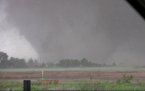
An early morning tornado, not the strongest, but the deadliest tornado of the outbreak. An EF5 tornado destroyed 75% of the town of McAlester, and killed 125 people. By 11:30 PM on October 1, a cluster of supercells developed over Oklahoma. The most strong one was located just southwest of McAlester. A Severe thunderstorm warning was put up for Pittsburg county at 11:50 PM for baseball size hail and 70 mile an hour winds. At 12:10 AM, a tornado was spotted outside of town. Sirens were broken, so there was no warning of the tornado coming. Just outside the sleepy town, a monster now EF4 was slowly pushing past the Pittsburg county line. Everyone continued to sleep, having know idea about what was about to happen to them. at 12:30 AM, the now EF5 tornado was moving closer towards the quiet town. at 12:42, with the tornado at peak intensity, the tornado entered town, obliterating structures, and killing everyone inside them. The tornado stripped a water tower to it's frame, and then ripped it from the ground at threw it a mile away. The tornado continued through town, destroying homes and throwing cars. The tornado rapidly weakened outside of town and dissipated completely within a couple minutes.
Other notable tornadoes[]
Lenexa, Kansas[]
A low end EF3 caused major damage to the town of Lenexa Kansas. Well built structures were severely damaged and had to be torn down. Cars were lifted and thrown for short distances. 3 were killed and 18 were injured.
Derby, Kansas[]
A high end EF4, with wind speeds of 200 mph or higher. 10 were killed and 25 injured. Several homes were completely destroyed. Many of which were well built.
Confirmed tornadoes[]
Oklahoma 12:00 - 2:00 AM[]
| EF scale | Location(s) | Times | Comments/damage |
|---|---|---|---|
| EF5 | McAlester-Krebs Oklahoma | 12:16-12:54 AM | Very strong, violent tornado affected much of the McAlester area. major ground scouring and structural damage was reported. |
| EF3 | Bug Tussle, Oklahoma | 12:52-1:11 AM | Tornado touched down of town and remained nearly stationary for much of it's life. |
| EF3 | Bug Tussle, Oklahoma | 1:11 - 1:34 AM | Huge Tornado. |
Arkansas 1:00 - 3:00 AM[]
| EF scale | Location(s) | Times | Comments/damage |
|---|---|---|---|
| EF3 | Springdale-Sonora, Arkansas | 1:04-1:22 AM | Beginning of tornado family. Strong houses were left with only interior walls remaining. |
| EF3 | Blue Springs Village-Pilgrims Rest, Arkansas | 1:21-1:45 AM | Second tornado of family. Gravestones in cemeteries were ripped from the ground, and trees were completely debarked or reduced to splinters. |
| EF4 | Pilgrims Rest-Eureka Springs, Arkansas | 1:49 AM- 2:18 AM | Final and strongest tornado of family. Homes were left in piles of rubble. |
Missouri 2:00-6:00 AM[]
| EF scale | Location(s) | Times | Comments/damage |
|---|---|---|---|
| EF4 | Cassville, Missouri | 2:57 AM-3:36 AM | Tornado destroyed a Walmart Superstore on the northwest side of town. |
| EF4 | Pleasant Ridge-SSW of Springfield | 3:49 AM-4:47 AM | A long track tornado with several large curves in it's path. The tornado plowed through villages between Pleasant ridge and Springfield, destroying nearly all structures in it's path. The tornado made a large turn for the west as it approached the town of Billings. The tornado continued west for about 20 miles before turning back east. The tornado then turned directly Northeast and threatened the city of Springfield. The tornado rapidly weakend and caused no damage to the Springfield area. |
| EF4 | NNE of Joplin - N of Webb City | 5:15 AM- 5:30 AM | A very wide Multiple Vortex tornado with a width of 2.1 miles wide. Estimated wind speeds of 245 mph. |
Kansas 5:00 AM-10:00 AM[]
| EF scale | Location(s) | Times | Comments/damage |
|---|---|---|---|
| EF4 | Fort Scott, Kansas | 5:55 AM-6:11 AM | Another very wide tornado with a width of 1.9 miles wide ripped through town at EF4 strength. |
| EF4 | NW of Mulvane-Derby-McConnell AFB | 7:12 AM- 8:02 AM | Tornado ripped through the town of Derby, completely demolishing homes and throwing cars hundreds of feet. |
| EF3 | Lenexa-Overland Park | 8:59 AM- 9:19 AM | Very strong tornado. |
Nebraska 10:00 AM-12:00 PM[]
| EF scale | Location(s) | Times | Comments/damage |
|---|---|---|---|
| EF3 | David City-West Point, Nebraska | 10:00 AM-10:20 AM | Rain wrapped tornado caused major damage between David City and West Point. |
| EF3 | Pierce-Newcastle Nebraska | 10:53 AM-11:23 AM | Tornado snapped hundreds of trees. |
| EF3 | Obert-Wynot-Yakton, Iowa | 11:21 AM-11:56 AM | Tornado hit a campground in Obert, killing 11 people, and snapping more trees. |
Iowa 12:00 - 4:00 PM[]
| EF scale | Location(s) | Times | Comments/damage |
|---|---|---|---|
| EF3 | Le Mars-Fort Dodge-Des Moines | 12:44 PM-2:00 PM | A long track tornado crossed countryside before slamming Des Moines, causing extreme damage. 13 people died, 12 of which were in the Des Moines area. |
| EF3 | Marshalltown-Cedar Rapids, Iowa | 2:03 PM- 3:01 PM | Another long track tornado which made several large turns. The town of Blairstown, Iowa was 60% destroyed by the twister. |
| EF3 | West Liberty-Clinton, Iowa | 2:59 PM- 3:46 PM | Large twister struck the south side of Clinton, leaving several homes either severely damaged or completely destroyed. |
Wisconsin 1:00 PM-6:00 PM[]
| EF scale | Location (s) | Times | Comments/damage |
|---|---|---|---|
| EF3 | Cuba City-Belmont, Wisconsin | 1:12 PM-1:34 PM | A high end EF3 tornado widely disputed for an EF4 rating. Winds reached 175 miles an hour, and over 100 homes were completely destroyed. 15 people died in this tornado. |
| EF3 | Madison-Milwaukee, Wisconisn | 3:55 PM- 4:43 PM | Tornado touched down as a waterspout on lake Monona, but moved ashore and started doing EF2 damage near the Northeast side of Milwaukee. The tornado destroyed several large buildings including supermarkets, trucking plants, and hotels. The tornado then started moving along route 94 as it exited the city. Route 94 was filled with chaos as the tornado moved toward the city. Vehicles were blasting down the highway at average speeds of 80 to 100 miles an hour. Drivers would lose control of there cars, fly of the road and become seriously injured. The chaos lead to cars smashing into each other, and the ambulance was unable to arrive on time, so people in critical condition would be left in there cars to die. As the tornado picked up speed, cars would attempt to escape of exits. The exits were packed with cars trying to get to safety. At 4:09 PM, the highway patrol called into the milwaukee police department, asking for them to send an emergency message to all radio stations. The message said: Attention, if you are currently travelling on highway 94, we would recommend to listen carefully to the instructions. The national weather service has issued a tornado emergency for all areas between Milwaukee and Madison. A violent tornado is on the ground about 8 miles west of Milwaukee, moving east at 40 miles an hour. We are sending police officers to all exits between Madison and Milwaukee. Please exit the highway on your closest highway exit. Local law enforcement will direct you to safety. Repeat... there is a violent tornado on the ground moving east at 40 miles an hour. Please leave the highway using your closest highway exit. Law enforcement will direct you to the closest shelter. The message would help hundreds of people escape the situation safely, and get to the closest shelter. The tornado then roared across the now empty highway, before weakening to an EF0 near Milwaukee. The emergency alert on the radios was said to be a large step forward in protecting the public from deadly situations. |
Kentucky 5:00 PM-6:00 PM[]
| EF scale | Location(s) | Times | Comments/damage |
|---|---|---|---|
| EF3 | Lexington-Paris, Kentucky | 5:05 PM-5:15 PM | A violent, yet short track tornado caused major damage, especially in the heavily populated areas of Lexington. |
Tennessee 5:00 PM-7:00 PM[]
| EF scale | Location(s) | Times | Comments/damage |
|---|---|---|---|
| EF3 | N of Cookville | 5:17 PM-5:25 PM | Large cone tornado. |
| EF3 | NW of Jackson-Murfreesboro | 5:40 PM-6:39 PM | An extremely long track tornado traveled nearly 160 miles from Jackson, Tennessee all the way to Murfreesboro. The twister left entire villages in piles of rubble, with homes left with only interior walls and rooms standing. |
| EF3 | Waverly-Coopertown | 6:39 PM-7:00 PM | Tornado caused intense ground scouring and structural damage. An overpass bridge over route 49 was damaged by the tornado, and collapsed on a car resulting in one death. |
Kentucky 6:00 PM-8:00 PM[]
| EF scale | Location(s) | Times | Comments/damage |
|---|---|---|---|
| EF3 | Fort Campbell-Bowling Green-N of Leitchfield | 6:45 PM-7:19 PM | A very slow moving tornado touched down near fort Campbell, Kentucky before progressing East-Northeast at only 5 miles an hour, causing major damage. The most intense damage was near the city of bowling green. The tornado then rapidly waned as it turned to the north, with isolated spots of EF1 damage. |
| EF3 | N of Lexington, Kentucky | 7:17 PM-7:28 PM | A strong, but short lived tornado caused low end EF3 damage North of Lexington. |
Indiana 7:00 PM-8:00 PM[]
| EF scale | Location(s) | Times | Comments/damage |
|---|---|---|---|
| EF3 | East Enterprise - Patriot, Indiana | 7:09 PM-7:21 PM | A large stovepipe plowed through areas between East Enterprise and Patriot. |
| EF3 | Patriot, Indiana - WSW of Cincinnati, Ohio | 7:24 PM-7:47 PM | Touched down near Patriot before crossing the Kentucky State line before curving east and crossing the Ohio state line and doing damage to Cincinnati. |
| EF3 | N of Friendship - Dillsboro, Indiana | 7:44 PM-7:57 PM | Wedge tornado resulted in major ground scouring and structural damage. |
October 3 Event[]


Convective outlook for October 3, 2040
After the tornadoes on October 1st and 2nd, the system began to weaken as it progressed towards the Northeast. 2 tornadoes touched down, and over 100 wind and hail reports were received by the Storm Prediction Center.
Confirmed tornadoes[]
Lowville, Pennsylvania[]
An EF2 tornado touched down causing major damage. It touched down near the intersection of Sunshine Lane and Brown Avenue around 6:15 AM before moving into town.
Ripley, New York[]


The Ripley Tornado hitting town.
An EF4 tornado first touched down about 300 yards offshore at 6:30 AM. It then started moving away from land at high speed. A fisherman was killed about a mile offshore as it continued to move west. The tornado then made a sharp turn to the east and started to move back towards land at 60 miles an hour. 3 other boaters were killed as the tornado pushed back towards land. It was then, the tornado moved back ashore along the west side of town, destroying several cottages. The tornado then picked up speed and moved quickly toward the central part of town, where it made another deep turn toward the Northwest. The tornado progressed up shore destroying more buildings before decaying near Lake Erie State Park.
Aftermath[]
Following the tornadoes, unspeakable damage was reported from all over the country, with the most extreme damage in the McAlester and Stillwater areas. Many parts of the country would never be the same again.